

Protected Wildlife Areas of the Cocos Marine Conservation Area (2021))

Context of Cocos Island National Park and the Bicentennial Marine Management Area with its current boundaries.
Thanks to the 2021 expansion, the protection and conservation of its seas – which constitute 92% of Costa Rica’s territory – from 2.7% to approximately 30%.
ACMC Wildlife Protected Areas (2001, 2011 y 2021)

Comparative map of Cocos Island National Park and Bicentennial Marine Management Area in 2001, 2011 and 2021.
The area of Cocos Island National Park increased from 2,034 km2 to 54,844 km2 and the Bicentennial Marine Management Area from 9,649 km2 to 106,285.56 km2.
Official coordinates of the vertices of the ASP (WGS-84)

WGS-84 geographic coordinates of the vertices of the Protected Wildlife Areas.
In this case, the 4 vertices of Cocos Island NP and 5 vertices of the Bicentennial WMA are shown.
Eastern Tropical Pacific Marine Corridor ASP (CMAR)

Map of the Protected Wildlife Areas that make up the Eastern Tropical Pacific Marine Corridor (CMAR).
The CMAR is a conservation and sustainable use initiative that seeks the adequate management of biodiversity and marine and coastal resources, through ecosystemic management, and through the establishment of joint regional governmental strategies.
Cocos Island Watersheds
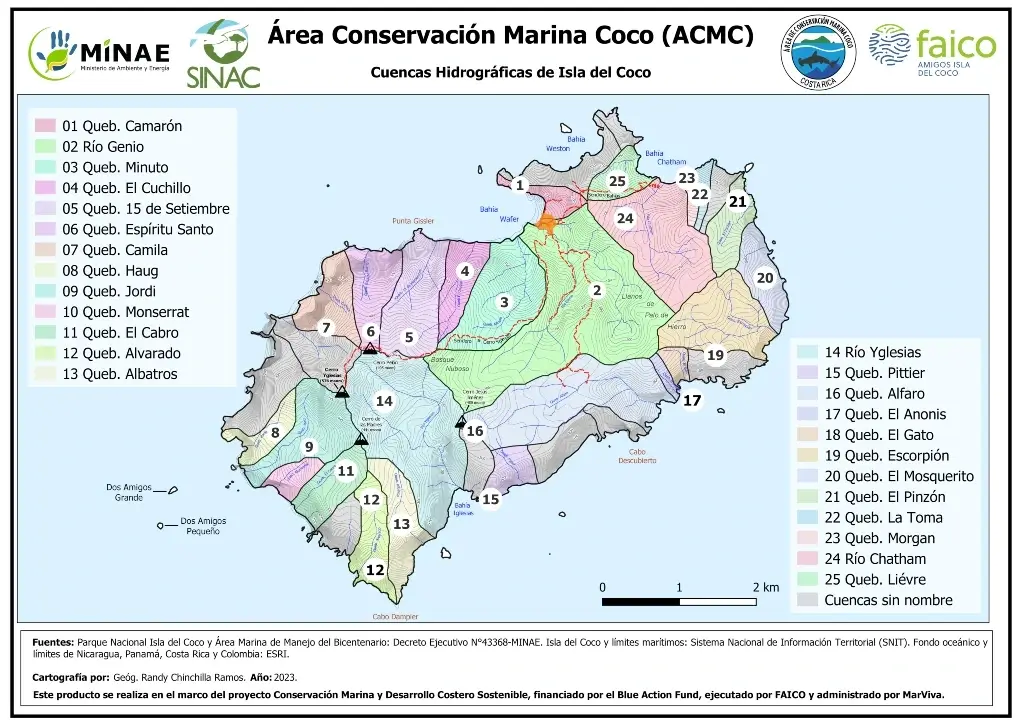
Map showing the location and extent of 25 sub-watersheds of Cocos Island.
Geological context of the Eastern Tropical Pacific

Geological context of the Eastern Tropical Pacific. Geological features such as faults, mountain systems, seamounts, tectonic plate boundaries and CMAR core island areas are shown.
Geomorphology of Cocos Island

Map of the geomorphology of Cocos Island that provides a visual representation of the shape and physical characteristics of the island terrain.
Physical map of Cocos Island

Physical map of Cocos Island with its main elements: contour lines, rivers, trails, among others.
Historical evolution of PSA boundaries

Maps showing the historical evolution of the Protected Wildlife Areas from their creation to their last modification.
Dive sites in the surroundings of Cocos Island

Detailed map of the dive sites around Cocos Island.
Distances between Cocos Island and Costa Rica

Map showing distances in kilometers from Wafer Bay and Chatham Bay to geographic extremes and to main departure docks.